
If you want to get outside and enjoy the beauty of nature, Austin is the perfect destination. With its warm weather and stunning landscapes, the city offers hiking trails perfect for beginners and experienced hikers. In this guide, we'll explore some of the best hiking trails in Austin, with information on trail difficulty, length, and what to expect. And to help you get to and from these excellent trails, we recommend using Texas Shuttle, a comfortable and convenient shuttle service that can take you to all these destinations and more. Hiking shuttle service Texas Shuttle service
Barton Creek Greenbelt
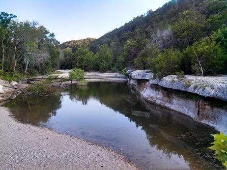
Barton Creek Greenbelt is one of Austin's most popular hiking trails, and for a good reason. The 7.25-mile trail offers beautiful views of limestone cliffs, waterfalls, and swimming holes. The trail is moderately complex and has a mix of shaded and exposed areas, so it's perfect for a hot summer day. The shuttle drop-off is at Spyglass Trailhead.
Mount Bonnell
For stunning views of the Austin skyline, head to Mount Bonnell. This short and easy hike is only 0.5 miles roundtrip, but the views from the top are breathtaking. You can see Lake Austin, the Pennybacker Bridge, and downtown Austin in the distance from here. The shuttle drop-off is at the base of the trail.
St. Edwards Park
St. Edwards Park is an excellent destination for hikers looking for a challenge. The 4-mile trail is moderately complex and offers beautiful views of the Hill Country. You'll pass by a creek and several small waterfalls along the way. The shuttle drop-off is at the entrance of the park.
River Place Nature Trail
River Place Nature Trail is a hidden gem in the northwest of Austin. The 5-mile trail is moderately complex and takes you through a beautiful forested area with several waterfalls and streams. The shuttle drop-off is at the entrance of the trail.
Wild Basin Wilderness Preserve
Wild Basin Wilderness Preserve is a 227-acre nature preserve that offers several trails of varying difficulty levels. The preserve is home to various wildlife, including deer, foxes, and birds. The shuttle drop-off is at the entrance of the preserve. Wild Basin trails
Bring plenty of water, sunscreen, and snacks, no matter which hiking trail you choose. And for a comfortable and convenient way to get to and from these trails, be sure to book your transportation with Texas Shuttle.

Frequently Asked Questions
What kind of views can I expect from Mount Bonnell?
You'll see Lake Austin, the Pennybacker Bridge, and downtown Austin from the top.
How long is the Barton Creek Greenbelt trail?
The Barton Creek Greenbelt trail is 7.25 miles long.
Are there any waterfalls on the River Place Nature Trail?
Yes, the River Place Nature Trail has several waterfalls and streams along its 5-mile route.
What wildlife might I encounter at Wild Basin Wilderness Preserve?
Wild Basin is home to various wildlife including deer, foxes, and birds.
More Great Austin Hiking Trails Worth Adding to Your List
Beyond the five trails covered above, the Austin area has several more standout hikes that locals return to again and again. Each of these offers a different side of Central Texas terrain — from creekside strolls to rugged Hill Country climbs — and all are within easy reach of major routes like MoPac (Loop 1), Texas 360, and I-35.
McKinney Falls State Park
Located just southeast of the city off U.S. Highway 183 near its junction with State Highway 71, McKinney Falls State Park is one of the closest state parks to downtown Austin. The park features Upper and Lower Falls, where Onion Creek spills over smooth limestone ledges. A network of hiking trails winds through the park, including routes that pass by the historic homestead of Thomas McKinney, one of Stephen F. Austin's original colonists. Trails range from easy creekside walks to longer routes through oak and juniper woodland. Note that this is a Texas State Park, so visitors should reserve entry in advance through the Texas Parks and Wildlife Department, especially on weekends, when the park frequently reaches capacity.
Mayfield Park and Nature Preserve
Tucked into the hills just off West 35th Street near the Pease Park corridor, Mayfield Park is best known for its resident peacocks and its historic cottage gardens, but the short nature preserve behind the gardens offers a surprisingly rugged taste of Hill Country terrain. It's an ideal quick hike for visitors staying near downtown or the University of Texas campus, and it pairs well with a stop at nearby Mount Bonnell.
Turkey Creek Trail
The Turkey Creek Trail in the Emma Long Metropolitan Park area, reached via City Park Road off Texas 360 Loop, is a favorite among Austin mountain bikers and hikers alike. The trail follows a creek through shaded cedar and oak forest, with plenty of rocky, rooty sections that keep the hike interesting. It's also one of the few Austin trails where dogs are allowed to swim off-leash along the creek, making it a popular pick for pet owners. City Park Road is narrow and winding, so drivers should take it slow — and parking fills quickly on warm weekends.
Ann and Roy Butler Hike-and-Bike Trail at Lady Bird Lake
If you want a hike without leaving the urban core, the Ann and Roy Butler Hike-and-Bike Trail circling Lady Bird Lake is the most accessible trail in Austin. The loop runs roughly ten miles along both banks of the Colorado River, crossing at landmarks like the Congress Avenue Bridge, the Pfluger Bridge, and the Boardwalk Trail on the south shore. The trail is flat, fully paved or crushed granite, and dotted with water fountains and restrooms — perfect for beginners, joggers, and anyone squeezing in a hike between meetings downtown.
Walnut Creek Metropolitan Park
In North Austin near U.S. Highway 183 and Lamar Boulevard, Walnut Creek Metropolitan Park offers a web of unpaved trails that follow the creek through a surprisingly wild-feeling corridor. The trails are shared with mountain bikers, and the terrain includes small climbs, creek crossings, and plenty of shade. It's a great choice for North Austin residents or travelers staying near the Domain who don't want to cross town for a trailhead.
The Hill of Life and the Barton Creek Greenbelt's Western End
Most visitors experience the Barton Creek Greenbelt from its central entrances, but the western end delivers the Greenbelt's most dramatic elevation change. The Hill of Life, accessed near the Scottish Woods Trailhead off Old Bull Creek Road, drops steeply down to Barton Creek, where hikers can connect to the creek bed and explore toward Sculpture Falls. It's a workout on the way back up, so bring more water than you think you need.
Austin Hiking Trails at a Glance
| Trail | Difficulty | Best For | General Location |
|---|---|---|---|
| Barton Creek Greenbelt | Moderate | Cliffs, swimming holes, waterfalls (seasonal) | South Austin, near MoPac and Barton Skyway |
| Mount Bonnell | Easy | Skyline and Lake Austin views | West Austin, off RM 2222 |
| St. Edwards Park | Moderate | Quiet Hill Country terrain | Northwest Austin, near Spicewood Springs Road |
| River Place Nature Trail | Moderate to strenuous | Stairs, waterfalls, forested canyons | Northwest Austin, near Texas 360 |
| Wild Basin Wilderness Preserve | Easy to moderate | Wildlife watching, short nature walks | West Austin, off Capitol of Texas Highway (360) |
| McKinney Falls State Park | Easy to moderate | Waterfalls, history, family hikes | Southeast Austin, near U.S. 183 and SH 71 |
| Turkey Creek Trail | Moderate | Shaded creekside hiking, dog-friendly swimming | West Austin, via City Park Road |
| Lady Bird Lake Hike-and-Bike Trail | Easy | Urban loop walk, beginner-friendly | Downtown Austin, around Lady Bird Lake |
When to Hike in Austin: A Seasonal Guide
Austin's trails are usable year-round, but the experience changes dramatically with the seasons.
Spring (March through May)
Spring is prime hiking season. Temperatures are mild, and Central Texas roadsides and greenbelts are famous for wildflowers, including the state flower, the bluebonnet. Barton Creek typically still has flowing water from winter rains, which means waterfalls like the ones along the Greenbelt and River Place Nature Trail are at their best. Weekends are busier, so arrive early.
Summer (June through August)
Summer in Austin is hot — regularly in the mid-to-upper 90s and above. If you hike in summer, go at sunrise, stick to shaded routes like Turkey Creek or the deeper sections of the Greenbelt, and carry significantly more water than usual. Trails with swimming holes, such as the Greenbelt's popular spots and McKinney Falls, become especially appealing.
Fall (September through November)
Fall brings a second window of excellent weather, and the crowds thin out after the back-to-school season. October and November are reliably comfortable for longer hikes like the full Greenbelt or the River Place Nature Trail's stair-heavy climbs.
Winter (December through February)
Winters are generally mild, with many pleasant hiking days, though cold fronts can bring freezes. Creek levels depend on rainfall, so check recent conditions before expecting waterfalls.
Know Before You Go: Austin Trail Tips
Watch for flash floods
Central Texas flash flooding is a real hazard, and low-water crossings along Barton Creek, Walnut Creek, and Onion Creek can rise quickly during storms. Never enter flooded trails or crossings, and check weather conditions before heading out — especially between spring and fall.
Parking is limited at most trailheads
Popular access points — including the Spyglass entrance to the Greenbelt near MoPac, the Twin Falls entrance off Barton Skyway, and the Mount Bonnell lot on Mount Bonnell Road — have small parking areas that fill early on weekends and nice-weather days. Arriving before mid-morning, carpooling, or using a shuttle service like Texas Shuttle removes the parking stress entirely and lets you start your hike at one trailhead and finish at another without worrying about a second vehicle.
Respect trail rules
Leash rules vary by park: leashes are required on most greenbelt and preserve trails, while the Turkey Creek Trail allows dogs off-leash along the creek. Swimming is popular in the Greenbelt but only when water is flowing and posted conditions allow it. State parks like McKinney Falls require advance day-use reservations and charge an entrance fee.
Carry the essentials
Austin's terrain is rocky, and shade can be sparse on exposed sections. Pack more water than you expect to drink, sun protection, sturdy shoes with good tread, and a snack. Cell coverage is generally good, but some canyon sections of the Greenbelt have dead zones.
Frequently Asked Questions
What is the most beginner-friendly hiking trail in Austin?
Mount Bonnell is the easiest short hike with the biggest payoff, and the Ann and Roy Butler Hike-and-Bike Trail around Lady Bird Lake offers a flat, paved option right downtown.
Which Austin trail has the most waterfalls?
The River Place Nature Trail is known for its waterfalls and streams, and Barton Creek Greenbelt features seasonal waterfalls such as those near the Twin Falls and Sculpture Falls areas.
Do I need a reservation for any Austin trails?
McKinney Falls State Park is a Texas State Park and recommends reserving day passes in advance through Texas Parks and Wildlife, since it often reaches capacity on weekends. City trails like the Greenbelt and Mount Bonnell do not require reservations.
Are dogs allowed on Austin hiking trails?
Most Austin trails allow leashed dogs. The Turkey Creek Trail is a well-known exception where dogs may swim off-leash along the creek. Always check posted rules at the specific trailhead.
Can you swim while hiking the Barton Creek Greenbelt?
Yes, swimming is popular in Barton Creek's pools and swimming holes when water levels are adequate. Flow depends on recent rainfall, so conditions vary throughout the year.
What is the longest hike in Austin proper?
The full Barton Creek Greenbelt is the longest continuous route at 7.25 miles, while the Ann and Roy Butler Trail loops roughly ten miles around Lady Bird Lake for those counting an urban trek as a hike.
How do I get to Austin trails without a car?
Many trailheads are far from bus routes, especially those along Texas 360 and City Park Road. Booking a ride with Texas Shuttle is the most convenient way to reach trailheads directly, and it lets you hike point-to-point without shuttling your own car back.